Salar de Uyuni (or Salar de Tunupa) is the world’s largest salt flat at 10 582 square kilometers (4 086 sq mi). It is in the Daniel Campos Province in Potosí in southwest Bolivia, near the crest of the Andes and is at an elevation of 3 656 meters (11 995 ft) above sea level.
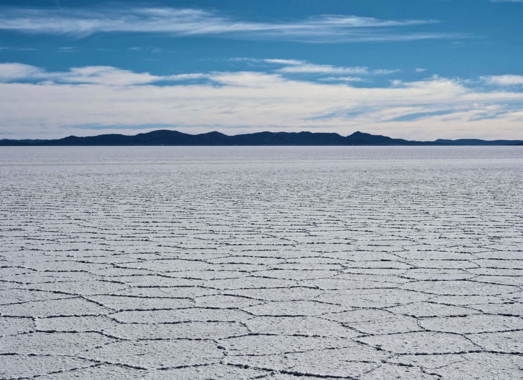
The Salar was formed as a result of transformations between several prehistoric lakes. It is covered by a few meters of salt crust, which has an extraordinary flatness with the average elevation variations within one meter over the entire area of the Salar. The crust serves as a source of salt and covers a pool of brine, which is exceptionally rich in lithium. It contains 50% to 70% of the world’s known lithium reserves, which is in the process of being extracted. The large area, clear skies, and exceptional flatness of the surface make the Salar an ideal object for calibrating the altimeters of Earth observation satellites.

The Salar serves as the major transport route across the Bolivian Altiplano and is a major breeding ground for several species of flamingos
Wikipedia
Salar de Uyuni is also a climatological transitional zone since the towering tropical cumulus congestus and cumulonimbus incus clouds that form in the eastern part of the salt flat during the summer cannot permeate beyond its drier western edges, near the Chilean border and the Atacama Desert.
Salar de Uyuni is part of the Altiplano of Bolivia in South America. The Altiplano is a high plateau, which was formed during uplift of the Andes mountains. The plateau includes fresh and saltwater lakes as well as salt flats and is surrounded by mountains with no drainage outlets.

The geological history of the Salar is associated with a sequential transformation between several vast lakes. Some 30 000 to 42 000 years ago, the area was part of a giant prehistoric lake, Lake Minchin.
Wikipedia
Its age was estimated from radiocarbon dating of shells from outcropping sediments and carbonate reefs and varies between reported studies. Lake Minchin (named after Juan B. Minchin of Oruro) later transformed into Paleo Lake Tauca having a maximal depth of 140 meters (460 ft), and an estimated age of 13 000 to 18 000 or 14 900 to 26 100 years, depending on the source. The youngest prehistoric lake was Coipasa, which was radiocarbon dated to 11 500 to 13 400 years ago. When it dried, it left behind two modern lakes, Poopó and Uru Uru, and two major salt deserts, Salar de Coipasa and the larger Salar de Uyuni. Salar de Uyuni spreads over 10 582 km2, which is roughly 100 times the size of the Bonneville Salt Flats in the United States. Lake Poopó is a neighbor of the much larger Lake Titicaca. During the wet season, Titicaca overflows and discharges into Poopó, which, in turn, floods Salar De Coipasa and Salar de Uyuni.
Lacustrine mud that is interbedded with salt and saturated with brine underlies the surface of Salar de Uyuni. The brine is a saturated solution of sodium chloride, lithium chloride, and magnesium chloride in water. It is covered with a solid salt crust varying in thickness between tens of centimeters and a few meters. The center of the Salar contains a few islands, which are the remains of the tops of ancient volcanoes submerged during the era of Lake Minchin. They include unusual and fragile coral-like structures and deposits that often consist of fossils and algae.
The area has a relatively stable average temperature with a peak at 21 °C in November to January and a low of 13 °C in June. The nights are cold all through the year, with temperatures between −9 °C and 5 °C. The relative humidity is rather low and constant throughout the year at 30% to 45%. The rainfall is also low at 1 mm to 3 mm per month between April and November, but it may increase up to 80 mm in January. However, except for January, even in the rainy season the number of rainy days is fewer than 5 per month.